The most significant change in global trade between 1450 and 1750 was the rise and involvement of the Europeans. Beginning with Portugal and Spain, European countries would commission the exploration, charting, and colonization of a huge portion of the world. The advancements that enabled them to do this, however, did not originate in a vacuum. Europeans adapted, improved, and synthesized the use of technologies and knowledge that came to them from elsewhere. European technological developments in cartography and navigation built on previous knowledge developed in the classical, Islamic, and Asian worlds.
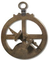
Navigation TechnologiesA mariner's astrolabe.Islamic civilization had long possessed the need for astronomical and geographic knowledge. Muslims schools were expected to pronounce daily prayer times, calculate the exact time of the holy month of Ramadan, and provide the faithful with the direction of Mecca for the purpose of prayer. To address these religious matters they developed the astrolabe which enabled them to solve "300 types of problems in astronomy, geography, and trigonometry." [1] Through Muslim Spain, the astrolabe entered Christian Europe. Borrowing the basic principles of the Islamic astrolabe, the Portuguese created the mariner's astrolabe, an instrument whose functions were limited to and designed specifically for the purpose of navigation. At sea, the mariner's astrolabe helped ships determine their latitude by aligning the instrument with the sun or a known star.
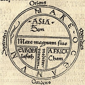
Cartography The sea voyages of the Europeans in this era could not have taken place without a revolution in the craft of cartography, or map making. European maps in the Middle Ages, called T-O maps because of their shape, were not intended as tools for navigation. These maps often placed Jerusalem in the center of the world and divided the world into the domains of Noah's three sons. A typical T-O Map dividing the world into the provinces of the sons of Noah from the Bible.Hence they were qualitative maps intended to make a religious statement about the world from a Christian point of view. They declared what was religiously important but were useless in bringing sailors back to port. [2]
This changed with European contacts with Byzantine and Islamic influences that had been increasing over the previous few centuries. Although writings of the Greek cartographer Ptolemy (90-168 C.E.) had been making their way into Europe in the previous period, few Europeans read Greek. With the increase of available classical authors and their translation into Latin, a new interest in Ptolemy's work emerged. [3] Combined with the growing desire for trade, navigation and cartography attracted some of the best academic minds of the 15th century who began to view the world, like Ptolemy, in a quantitative way.[4] They believed mathematics corresponded with the actual way the world was.[5] A change in The Portuguese caravel.The Spanish Galleon.mentality meant that the world was now conceived in a mathematical and rational way. Cartography was concerned with making maps that resemble the features of geography as they actually existed rather than making a theological statement about the world. Merchants could now use maps to plot new routes to and from desired locations and their experiences and information was in turn applied to the latest maps. The craft of this new quantitative method of map-making and the training required for the new instruments of navigation were taught in the city of Lisbon, Portugal.
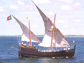
Innovations in Ship Design Another European advancement based on previous technologies was the caravel, a light, fast, and maneuverable ship first devised by the Portuguese. (Columbus constantly praised his favorite ship, the Niña which along with the Pinta seemed to be a caravel.[6]) Lighter, requiring a smaller crew, and able to carry more cargo than the typical oar-driven Mediterranean ships, [7] the caravel adopted the lateen sail first pioneered by Arab merchants in the India Ocean. This gave these ships the ability to tack into the face of the wind. The caravel was able to carry a large cargo with an inordinately small crew, thus decreasing the cost of shipping and increasing profits. Developing about a century after the caravel was Note the indirect route (in red) of the return to Portugal from the western coast of Africa. The westerlies made this the more efficient route.the Spanish galleon, a large multi-deck ship with at least three or four masts. The forward sails were large rectangular power sails with the last mast usually carrying a lateen sail. These ships were the primary vessels of the Spanish Treasure Fleet and were capable of carrying an enormous volume of cargo. They carried most of the slaves across the Atlantic via the dreaded Middle Passage. Europeans were the first to mount firearms on their ships, outfitting their caravels and galleons with broadside canon. Thus armed, these ships gave Europeans the capacity to project unprecedented power.
Knowledge of Wind and Sea Currents Europeans were also aided by their growing familiarity with the global environment and their adaptation to it. The Portuguese learned that the most efficient maritime route between two points is not always a strait line. This could involve fighting the wind and sea currents. Consequently, they developed a strategy known as the volta do mar, or turn of the sea. Often going far out of their way, the Portuguese and other European sailors learned instead to work with the currents. For example, when Vasco da Gama sought a route to the Indian Ocean around Africa, he sailed nearly to the coast of Brazil before he caught the westerlies that took him around the Cape of Good Hope at the southern tip of Africa.[8] Knowledge of such trade winds allowed sailors to be more efficient by using, rather than going against, the grain of nature.
↑Science and Technology in World History (2006, 2nd ed.) James E. McClellan III and Harold Dorn, p.107.
↑The Foundations of Early Modern Europe, 1460-1559. (1994) Eugene F. Rice, Jr. and Anthony Grafton, pp.126-27.
↑Renaissance Thought and its Sources. (1979) Paul Oskar Kristeller, p.121.
↑The Discoverers: A History of Man's Search to Know his World and Himself. (1993) Daniel Boorstin, pp.146-156.
↑The Scientific Revolution and the Origins of Modern Science. (1997) John Henry, p.15.
↑ "The Niña, the Santa Cruz, and Other Caravels as Described in the Livro de armadas and Other Spanish Records." Lyon, E., The American Neptune. (1993) 53.4:239-46
↑Science and Technology in World History, McClellan, p.198.
↑Traditions and Encounters. (2006. 3rd ed.) Jerry Bentley, et al., p.604.