One of most important features of this time period (1450-1750) is the integration of both hemispheres into the world's first truly global network of trade. New technologies and methods of financing enabled trans-Atlantic trade and altered previous patterns of exchange. The ensuring new encounters spread culture, religion, new foods, and disease across the globe. Demographic changes were volatile, with some areas experiencing drastic changes because of the introduction of new foods while other areas, such as the Americas, were devastated with the introduction of new diseases.
I. In the context of the new global circulation of goods, there was in intensification of all existing regional trade networks that brought prosperity and economic disruption to the merchants and governments in the trading regions of the Indian Ocean, Mediterranean, Sahara, and overland Eurasia.
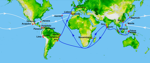
The voyage of Columbus inaugurated a network of global trade that connected both hemispheres. Silver from the New World was minted into the peso de ocho, a widely accepted currency that connected major trade systems. In the Pacific, the Spanish colony of Manila connected the New World with Asia markets; much of the New World's silver ended up in China. Despite this new level of global connectivity, this era saw major disruptions and changes in trade networks. Attempts by Portugal and Spain to monopolize trade in the Indian Ocean led to the down fall of the Swahili cities and the fall of Malacca. In Africa, the incorporation of West Africa into the Atlantic system drew the focus of trade from Trans-Saharan to the west. The fall of Constantinople to the Muslim Ottomans and Vasco DaGama’s maritime route to the Indian Ocean lessened Europe’s dependence upon Silk Road trade. The Atlantic System would emerge as the premier trade system in this era.
II. European technological developments in cartography and navigation built on previous knowledge developed in the classical, Islamic, and Asian worlds, and included the production of new tools, innovations in ship designs, and an improved understanding of global wind and current patterns--all of which made transoceanic travel and trade possible.
The most significant change in global trade between 1450 and 1750 was the rise and involvement of the Europeans. Beginning with Portugal and Spain, European countries would commission the exploration, charting, and colonization of a huge portion of the world. The advancements that enabled them to do this, however, did not originated in a vacuum. Europeans adapted, improved, and synthesized the use of technologies and knowledge deriving from many cultures.
Navigation TechnologiesA mariner's astrolabe.Islamic civilization had long possessed the need for astronomical and geographic knowledge. Muslims schools were expected to pronounce daily prayer times, calculate the exact time of the holy month of Ramadan, and provide the faithful with the direction of Mecca for the purpose of prayer. To address these religious matters they developed the astrolabe which enabled them to solve "300 types of problems in astronomy, geography, and trigonometry." [1] Through Muslim Spain, the astrolabe entered Christian Europe. Borrowing the basic principles of the Islamic astrolabe, the Portuguese created the mariner's astrolabe, an instrument whose functions were limited to and designed specifically for the purpose of navigation. At sea, the mariner's astrolabe helped ships determine their latitude by aligning the instrument with the sun or a known star.
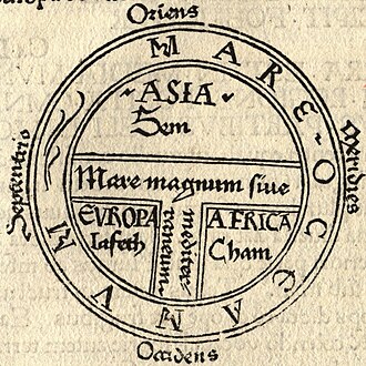
Cartography The sea voyages of the Europeans in this era could not have taken place without a revolution in the craft of cartography, or map making. European maps in the Middle Ages, called T-O maps because of their shape, were not intended as tools for navigation. These maps often placed Jerusalem in the center of the world and divided the world into the domains of Noah's three sons. A typical T-O Map dividing the world into the provinces of the sons of Noah from the Bible.Hence they were qualitative maps intended to make a religious statement about the world from a Christian point of view. They declared what was religiously important but were useless in bringing sailors back to port. [2]
This changed with European contacts with Byzantine and Islamic influences that had been increasing over the previous few centuries. Although writings of the Greek cartographer Ptolemy (90-168 C.E.) had been making their way into Europe in the previous period, few Europeans read Greek. With the increase of available classical authors and their translation into Latin, a new interest in Ptolemy's work emerged. [3] Combined with the growing desire for trade, navigation and cartography attracted some of the best academic minds of the 15th century who began to view the world, like Ptolemy, in a quantitative way.[4] They believed mathematics corresponded with the actual way the world was.[5] A change in The Portuguese caravel.The Spanish Galleon.mentality meant that the world was now conceived in a mathematical and rational way. Cartography was concerned with making maps that resemble the features of geography as they actually existed rather than making a theological statement about the world. Merchants could now use maps to plot new routes to and from desired locations and their experiences and information was in turn applied to the latest maps. The craft of this new quantitative method of map-making and the training required for the new instruments of navigation were taught in the city of Lisbon, Portugal.
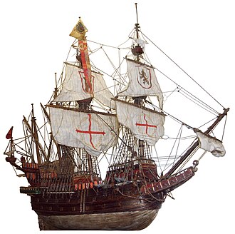
Innovations in Ship Design Another European advancement based on previous technologies was the caravel, a light, fast, and maneuverable ship first devised by the Portuguese. Columbus constantly praised his favorite ship, the Niña which along with the Pinta seemed to be a caravel.[6] Lighter, requiring a smaller crew, and able to carry more cargo than the typical oar-driven Mediterranean ships, [7] the caravel adapted the lateen sail first pioneered by Arab merchants in the India Ocean. This gave these ships the ability to tack into the face of the wind. The caravel was able to carry a large cargo with an inordinately small crew, thus decreasing the cost of shipping and increasing profits. Developing about a century after the caravel was Note the indirect route (in red) of the return to Portugal from the western coast of Africa. The westerlies made this the more efficient route.the Spanish galleon, a large multi-deck ship with at least three or four masts. The forward sails were large rectangular power sails with the last mast usually carrying a lateen sail. These ships were the primary vessels of the Spanish Treasure Fleet and were capable of carrying enormous cargo. They carried most of the slaves across Atlantic via the dreaded Middle Passage. Europeans were the first to mount firearms on their ships, outfitting their caravels and galleons with broadside canon. Thus armed, these ships gave Europeans the capacity to project unprecedented power.
Knowledge of Wind and Sea Currents Europeans were also aided by their growing familiarity with the global environment and their adaptation to it. The Portuguese learned that the most efficient maritime route between two points is not always a strait line. This could involve fighting the wind and sea currents. Consequently, they developed a strategy known as the volta do mar, or turn of the sea. Often going far out of their way, the Portuguese and other European sailors learned instead to work with the currents. For example, when Vasco da Gama sought a route to the Indian Ocean around Africa, he sailed nearly to the coast of Brazil before he caught the westerlies that took him around the Cape of Good Hope at the southern tip of Africa.[8] Knowledge of such trade winds allowed sailors to be more efficient by using, rather than going against, the grain of nature.
III. Remarkable new transoceanic maritime reconnaissance occurred in this period.
A. The Voyages of Admiral Zheng HeThe most extravagant maritime outreach early in this period was that of the Chinese. After the peasant revolt that threw out the Mongols and established the Ming Dynasty, the Chinese commissioned 7 major voyages under the leadership of admiral Zheng He. With an estimated 317 ships and a staff of 27,000 men, [9] Zheng He set out to establish the reputation of the Ming in the Indian Ocean. He sailed initially to southeast Asia and India but his final three voyages reached as far as the Swahili coast of east Africa. Unlike the European voyages that began a few decades later, these Chinese expeditions were not driven by commercial interests or attempts at conquest. They were diplomatic in nature. On his two year voyage of 1431-1433, Zheng He established for China 20 tributary and diplomatic relations across the entire rim of the Indian Ocean. [10] Unfortunately for Zheng He, a change of power in imperial China brought these voyages to an end. A new emperor, under the influence of powerful Confucians long suspicious of these voyages, withdrew funds for these diplomatic missions. The official records of Zheng's voyages were destroyed and the large treasure ships of the Chinese were banned. China began to focus instead on establishing internal stability over reaching out to the world.
B. Unaffected by the ravages of Europe's 100 Years War and Spain's civil strife, Portugal became the first European nation to embark on a program of exploration. King John's son, Prince Henry, was motivated by a crusading zeal to convert heathens to Christianity and an economic zeal to gain access to west Africa's legendary sources of gold. Henry's capture of the Muslim city of Ceuta in 1415 opened the western coast of Africa to Portuguese exploration, and by the year of Henry's death in 1460 his country had arrived in The location of Ceuta. Its fall to Prince Henry encouraged the Portuguese exploration of Africa's west coast.Guinea on Africa's western coast. Soon African gold was flowing by sea from west Africa directly to Iberia rather than across the trans-Saharan caravan routes. Algiers and Tunis in north Africa were economically devastated by this rerouting of trade. Portugal got rich. [11] As contacts with west African societies continued the Portuguese began trading in slaves.
After a dispute with his father, Prince Henry returned home to Portugal but avoided the capital of Lisbon where he could have easily gained a comfortable royal job. Instead, he settled in the remove coastal town of Sagres which he turned into a center of navigational studies and cartography. Now called Prince Henry the Navigator, he collected fresh information from newly arrived sailors to produce the most current maps possible. The compass, thought by many Europeans to be driven my occult powers, was disenchanted of superstition and its use expanded and refined. Since initial Portuguese voyages traveled north and south exploring Africa, more precise means of measuring latitude were researched. Borrowing elements of Arabic shipbuilding, Prince Henry and his engineers designed the famous caravel, mentioned above. All the elements needed for global exploration were brought together by Prince Henry at Sagres. Portugal was poised to take the lead, albeit brief, in the exploration and exploitation of the globe. [12]
Equipped with new maritime instruments and knowledge, the Portuguese accomplished many "firsts" in global exploration. In 1487 Bartholomew Diaz sailed his caravel around the southern tip of Africa, the first European to do so (his crew refused to press on to India). Then Vasco da Gama became the first to sail all the way to India in 1498; Europeans had found the illusive water route to the lucrative Indian Ocean trade network. The Portuguese strategy in the Indian Ocean was to dominate trade through the use of firepower, intimidation, and brutality. In the long run they were never able to completely monopolize this network but did succeed in building a trading-post empire which gave them a significant share of the spice and slave trade. With over 50 trading posts from southeast Asia to Africa's west coast, they attempted to force merchants to call at these ports and pay duties. They also required merchants to purchase passports from them; sailors caught at sea without one were mutilated and had their cargo confiscated. Despite these grand plans, the Portuguese had neither the manpower nor the fleet to carry out their demands. Many Indian Ocean merchants took their chances and sailed without passports or paying dues at Portuguese trading-posts. And the Spanish, English and Dutch sailors hired by the Portuguese to work their fleet took the knowledge of the seas back to their respective countries who were organizing their own expeditions to Asia. [13] The Portuguese began the explorations but were soon to be strong-armed out of the way by their European neighbors.
The Portuguese Empire, including the New World (Brazil), West Africa (Angola), and the trading-posts of the Indian Ocean.
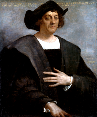
C. In 1476 a 25Christopher Columbus year old Christopher Columbus washed onto the Portuguese shore with a broken oar he had used as a float. The cargo ship on which he had been a crew member was sunk by a French fleet. As fortune would have it, the place where he reached the shore was only a few miles from Sagres, the location of Prince Henry's research center of navigation and cartography. Having grown up in Genoa on the Italian coast, Columbus had long possessed a fascination with sailing. But his time in Portugal, particularly Lisbon, would prove to be the most formative for what he would unwittingly accomplish.
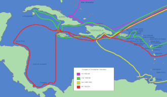
TheThe routes of Columbus in the Caribbean. idea that sailing west would led one to Asia was not new. What was novel about Columbus was his conviction that the distance between Europe and Asia to the west was not significant. Basing his argument on Marco Polo's description of the distance across Eurasia and Ptolemy's longitudinal calculations, Columbus vastly underestimated the distance of a western route to Asia. Nevertheless, he set out enthusiastically to convince the monarchs of Europe the same and gain funding for his journey. After a series of rejections, Ferdinand and Isabella of newly united Spain decided to pay for Columbus. In October of 1492 he sighted land in what he believed to be Asia. Columbus would make four voyages across the Atlantic and seems to have died not knowing that he had failed.
Columbus did not actually discover anything, nor was he the first European to make this crossing. Nonetheless, his journey is very important historically because he initiated a world-transforming encounter between two hemispheres of this planet. There would be profound cultural, demographic, political and social consequences.
References
↑Science and Technology in World History (2006, 2nd ed.) James E. McClellan III and Harold Dorn, p.107.
↑The Foundations of Early Modern Europe, 1460-1559. (1994) Eugene F. Rice, Jr. and Anthony Grafton, pp.126-27.
↑Renaissance Thought and its Sources. (1979) Paul Oskar Kristeller, p.121.
↑The Discoverers: A History of Man's Search to Know his World and Himself. (1993) Daniel Boorstin, pp.146-156.
↑The Scientific Revolution and the Origins of Modern Science. (1997) John Henry, p.15.
↑ "The Niña, the Santa Cruz, and Other Caravels as Described in the Livro de armadas and Other Spanish Records." Lyon, E., The American Neptune. (1993) 53.4:239-46
↑Science and Technology in World History, McClellan, p.198.
↑Traditions and Encounters. (2006. 3rd ed.) Jerry Bentley, et al., p.604.
↑China: A New History. (2006) John K. Fairbank and Merle Goldman, p.138.