File:Varangian routes.png
Jump to navigation
Jump to search

Size of this preview: 800 × 555 pixels. Other resolutions: 320 × 222 pixels | 872 × 605 pixels.
Original file (872 × 605 pixels, file size: 859 KB, MIME type: image/png)
Summary
| Description |
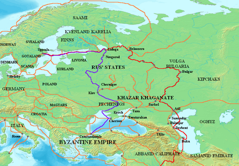
English: Map showing the major Varangian trade routes, the Volga trade route (in red) and the Trade Route from the Varangians to the Greeks (in purple). Other trade routes of the 8th–11th centuries shown in orange.
Français : Carte montrant les principales routes commerciales varègues (Route commerciale de la Volga en rouge, Route commerciale des Varègues aux Grecs en violet). Les autres routes (8°-11° siècle) sont en orange.
Русский: Основные варяжские торговые пути: Волжский торговый путь (красный) и Путь из варяг в греки (фиолетовый). Оранжевым цветом показаны другие торговые пути VIII–XI веков. |
||||||||
| Source |
The following source corroborates the Volga route between the Gulf of Finland and Atil, although it gives a different Western route, over Smolensk:
|
||||||||
| Author | Briangotts | ||||||||
| Permission (Reusing this file) |
I, the copyright holder of this work, hereby publish it under the following licenses:
You may select the license of your choice. |


|
This map image could be re-created using vector graphics as an SVG file. This has several advantages; see Commons:Media for cleanup for more information. If an SVG form of this image is available, please upload it and afterwards replace this template with
{{vector version available|new image name}}.
It is recommended to name the SVG file “Varangian routes.svg”—then the template Vector version available (or Vva) does not need the new image name parameter. |
File history
Click on a date/time to view the file as it appeared at that time.
| Date/Time | Thumbnail | Dimensions | User | Comment | |
|---|---|---|---|---|---|
| current | 05:29, 3 October 2023 | | 872 × 605 (859 KB) | OrionNimrod | Restore original: "Wallachians" added by Romanian user, however it was no Wallachia in the 8-11th c: British historian, Martyn Rady - Nobility, land and service in medieval Hungary (p91–93): the sources before the 13th century do not contain references to Vlachs anywhere in Hungary and Transylvania or in Wallachia. Byzantine sources mentioned Vlachs all deep in the Balcan. Also map should make by academic historians not by personal POV. |
File usage
The following page uses this file: